Pune Then and Now: A Look at How the City Has Transformed Over the Years
Pune, 15th August 2026: Pune, or as it was known then, Poona, has always held an important place in India’s history. From the Mughals to the British, no chapter of the city’s story is complete without an anecdote about Poona.
Over the years, the city has grown immensely, and so have its people. Yet, tucked into its bustling streets and familiar landmarks are memories of a Pune that once was, with each corner holding a story close to the hearts of those who call the city home.
This Independence Day, let’s take a walk through the lanes of Poona before Independence, revisit some of its most familiar landmarks, and see how the city has transformed right before our eyes.
Pune Then. Pune Now.
01. FERGUSSON COLLEGE / FC ROAD: Historic Image | 2026
Fergusson College was established in 1885, and its Main Building dates to the early years of the institution. The historic photograph shows a much quieter campus approach, with students walking and bicycles gathered outside the building. Today, the college remains one of the defining landmarks of FC Road, but the world around it has changed dramatically.
FC Road has evolved from a greener, quieter road into one of Pune’s busiest student and commercial stretches, with cafés, shops, parked two-wheelers and heavy pedestrian movement. The college remains the constant; the city around it has grown.
The college stayed, FC Road grew and evolved around it.
Note: The old photograph’s exact year is not independently verified.
02. DECCAN GYMKHANA: 1923 | 2026
This one is slightly different from the others because the building itself is the Then-and-Now subject.
The Deccan Gymkhana Post Office building dates to 1923, while the post office began functioning there in 1943. The old architecture: stone walls, wooden shutters and decorative detailing — still survives, even as the road outside has become far busier.
Cars, two-wheelers, commercial signage and modern infrastructure now surround a building that has been part of the neighbourhood for more than a century.
A century later, the building is still here. The street around it isn’t the same.
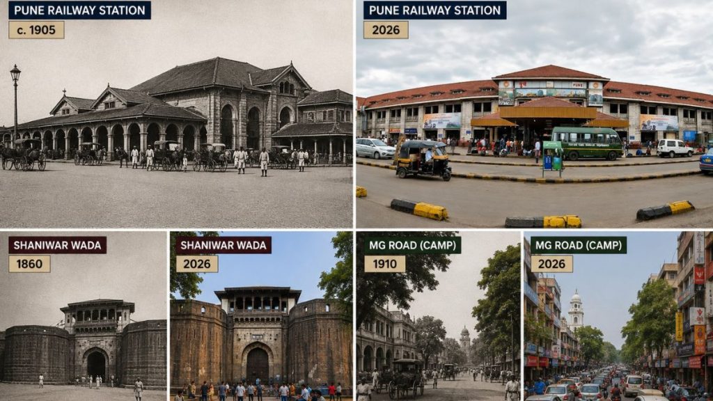
03. PUNE RAILWAY STATION: c. 1905 | 2026
Around 1905, Pune Railway Station, then Poona Station had a very different setting. The archival photograph shows the station surrounded by open ground, horse-drawn transport and a far smaller volume of passengers and traffic.
Today, the station is one of Pune’s busiest transport gateways. The building remains recognisable, but the scene outside has transformed into a constant flow of passengers, taxis, autos, cars and two-wheelers.
The contrast is particularly striking. IRFCA identifies this image as “Poona station about 100 years ago. Pune, About 1905” and credits it as an image from a postcard in the David Churchill collection.
04. CAMP / M.G. ROAD: 1910 | 2026
Before it became today’s M.G. Road. This stretch was known as Main Street. A 1910 postcard shows a broad, tree-lined road with shops, pedestrians and tongas moving through the Camp area.
More than a century later, the road is still one of Camp’s most recognisable commercial streets, but the rhythm is very different. Cars, motorcycles, dense signage and pedestrians now fill the same stretch.
The old photograph also captures something that is easy to miss today: Main Street was already a major shopping destination more than 100 years ago.
05. LAXMI ROAD: Historic Photograph | 2026
Laxmi Road has been one of Pune’s defining shopping streets for generations. The road as we know it today was widened in 1952, after earlier planning and development. Historical photographs show a much less crowded street, while today’s Laxmi Road is packed with shops, pedestrians, parked two-wheelers and traffic.
The Pune-Then-and-Now archive makes the contrast particularly clear, describing the old Laxmi Road as a much more open street compared with the crowded shopping district it is today.
06. SHIVAJINAGAR CIRCLE: Date Unverified | 2026
The vintage Shivajinagar Circle photograph captures a very different kind of Pune. Cyclists dominate the road, the buildings are low-rise and the streetscape is relatively open, with small shops lining the intersection.
Today, Shivajinagar is one of the city’s busiest central areas, with much heavier traffic, commercial development and a far greater number of two-wheelers and vehicles.
This is exactly the kind of image where a match-cut transition will work beautifully, keep the road junction and shop alignment consistent and let the traffic change before the viewer’s eyes.
07. SHANIWAR WADA: 1860 | 2026
Shaniwar Wada was built in 1732 and became the seat of the Peshwas. The 1860 photograph shows the fort in a far more open landscape, with considerably less development surrounding its walls.
Today, the fort remains one of Pune’s most recognisable heritage landmarks, but it sits within a dense urban environment. Buildings, roads, traffic and the modern city now surround what was once a much more open setting.
The Pune-Then-and-Now archive makes this contrast particularly clear, noting how the Wada is now surrounded by what it describes as a “concrete jungle”, compared with the natural surroundings visible in older photographs.