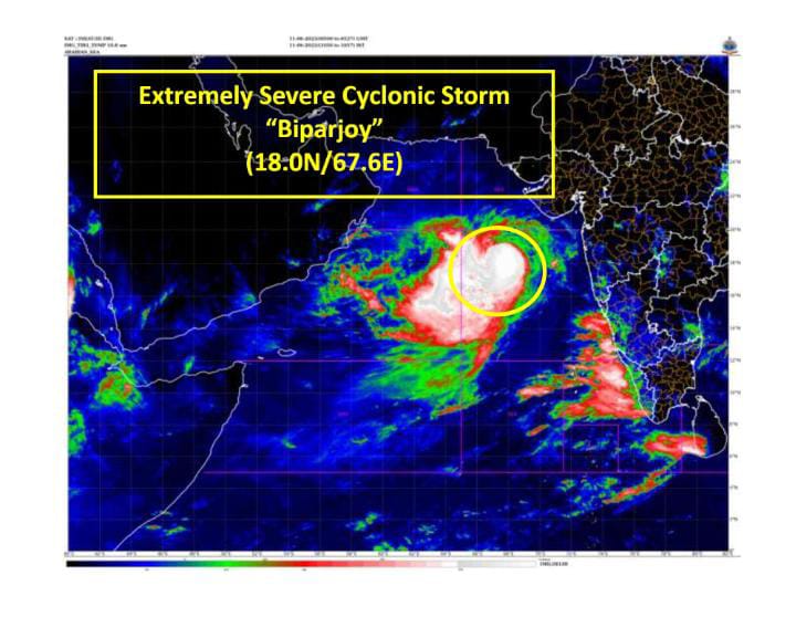
Extremely Severe Cyclonic Storm “Biparjoy” Intensifies, Expected to Cross Saurashtra-Kutch Coast
Pune, 11th June 2023: The Indian Meteorological Department’s weather forecasting head, Dr. Anupam Kashyapi, has issued a statement regarding the intensification of the very severe cyclonic storm “Biparjoy” over the east-central Arabian Sea.
Dr. Kashyapi warns that the cyclone has now developed into an extremely severe cyclonic storm and is currently centered near latitude 18°N and longitude 67.6°E, about 580 km west-southwest of Mumbai.
The storm has been moving north-northeastwards at a speed of 9 kmph over the past six hours. Dr. Kashyapi predicts that it will continue its northward trajectory until the morning of June 14th, after which it will shift to a north-northeastward path. The cyclone is expected to make landfall between Mandvi (Gujarat) and Karachi (Pakistan) around noon on June 15th as a very severe cyclonic storm. It is anticipated to have a maximum sustained wind speed of 125-135 kmph, with gusts reaching up to 150 kmph.
Dr. Kashyapi emphasized that the cyclone poses a significant threat to the coastal areas of Saurashtra-Kutch and adjoining parts of Pakistan. Residents and authorities in these regions are advised to take necessary precautions and closely monitor the updates from the weather department.
In addition to the cyclone, Dr. Kashyapi also provided information on the progress of the monsoon in various parts of the country. He stated that favorable conditions are expected for the further advancement of the Southwest monsoon into several areas. These include central Arabian Sea, Karnataka, Maharashtra, Tamil Nadu, Andhra Pradesh, west-central Bay of Bengal, northwest Bay of Bengal, northeastern states, and parts of Sub-Himalayan West Bengal, Sikkim, and Bihar. The monsoon is likely to make its presence felt in these regions within the next 48 hours.