Pune District Received Five Percent Excess Rainfall Till Now
Manasi Saraf Joshi
Pune, 22 July 2021: Although the progress of south-west monsoon this year was halted for a long time, from last week the monsoon activity has picked-up the pace with Maharashtra State receiving 22% excess rainfall so far.
While talking to Punekarnews.in , Indian Meteorological Department, Weather head, Anupam Kashyapi said, “The average rainfall the four meteorological department of Maharashtra viz Konkan-Goa, Madhya Maharashtra, Marathwada and Vidharba from the beginning of South-west monsoon is 425.4 mm. Till today (Thursday, July 22, 2021) the state has received 518.8 mm rainfall. This is 22% more than the average”.
Kashyapi also added that till now four districts of the State Nandurbar, Dhule, Akola and Gondia are rainfall deficient.
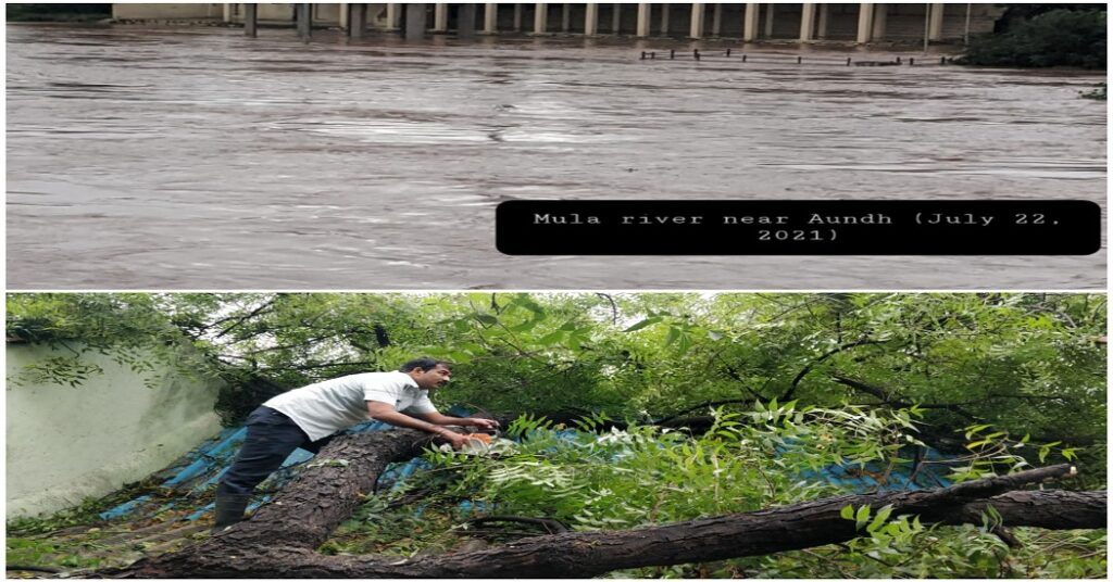
Pune district received only five percent excess rainfall
Meanwhile, the normal rainfall Pune district received is 383.1 mm from June till now. “After the rainfall activity has picked up in the state, the district has received only five percent more rain”, Kashyapi informed.
“The rainfall activity in the State will reduce from Friday onwards with isolated events of heavy to heavy rainfall in Konkan-Goa, Madhya Maharashtra. While there will be rainfall activity in all the four major meteorological regions of Maharashtra State”, Kashyapi stated.
Heavy rains due to low pressure belt
The state along with various parts of the country especially, the north-western zone is receiving good rainfall owing to the low-pressure belt over Bay of Bengal. The western end of monsoon trough at mean sea level has moved slightly southward but still runs north of its normal position. It is likely to shift to the normal position during next 3 days. Its eastern end now runs south of its normal position dipping to east central Bay of Bengal.
Under the influence of the cyclonic circulation over Northwest Bay of Bengal & neighbourhood, a Low Pressure Area has formed over the same region. It is likely to move west-northwestwards along the monsoon trough during next 2-3 days. An off-shore trough at mean sea level runs from south Gujarat coast to Kerala coast. It is likely to persist during next 2-3 days.
Forecast and warning
Fairly widespread to widespread rainfall with isolated heavy falls very likely over Himachal Pradesh and Uttarakhand on 22nd and 23rd which likely to increase to isolated heavy to very heavy falls on 25th and 26th July over these areas. Scattered to fairly widespread over plains of northwest India during next 3 days with enhanced rainfall activity thereafter with isolated heavy to very heavy falls over Uttar Pradesh on 25th & 26th July.
Light to Moderate rainfall at isolated places very likely over Delhi during next 24 hours. Fairly widespread to widespread rainfall with isolated heavy to very heavy falls very likely to continue over west coast during next 2-3 days with reduction thereafter. Isolated extremely heavy falls also very likely over Konkan & Goa & adjoining Ghat areas of Madhya Maharashtra and Coastal Karnataka today, the 22nd July.
Increase in rainfall activity over northeast India likely on 26th July with widespread-to-widespread rainfall with isolated heavy to very heavy falls over these areas.
Cities with record rainfall
Mahabaleshwar: 480 mm ( town had received highest rainfall in one day on July 7, 1977—439.8 mm)
Jawahar:434 mm
Wada: 418 mm
Matheran: 331
Ratnagiri: 252
Pune: 5.2 mm
Also read Pune: Many Pune Trains Canceled, Short Terminated, Rescheduled Due To Heavy Rains
Join our WhatsApp Group, Telegram, and Twitter for every update about Pune and PCMC