Red Alert Issued for Ghat Regions Near Pune; IMD Warns of Extremely Heavy Rainfall, Advises Caution

Pune, 7th July 2025: The India Meteorological Department (IMD) has sounded a red alert for the ghat regions surrounding Pune for Monday, warning of extremely heavy rainfall at isolated locations. City areas, meanwhile, are expected to receive light to moderate showers under a generally cloudy sky.
Rainfall in last 24 hours till 9 am on Monday:
KURVANDE (LONAVALA) 77.5
BHOR 58.5
NIMGIRI 51.0
CHINCHWAD 27.0
TALEGAON 21.5
LAVALE 18.0
NARAYANGOAN 17.0
DUDULGAON 15.5
RAJGURUNAGAR 14.0
NDA 14.0
SHIVAJINAGAR 8.9
LOHGAON 8.0
MAGARAPATTA 7.0
DHAMDHERE 4.0
HADAPSAR 3.5
PURANDAR 3.0
KOREGAON PARK 2.0
BARAMATI 0.8
HAVELI 0.5
The IMD has also placed nearby districts such as Kolhapur, Satara, Nashik, Raigad, Ratnagiri, Thane, Palghar, and Sindhudurg under an orange alert, especially in their hilly and coastal areas. The department has issued a strict advisory to avoid travel to ghat regions and vulnerable spots, citing risks of landslides, mudslides, and falling rocks.
“Given the rainfall intensity expected, we urge citizens to stay away from hilly terrains and low-lying areas,” said an IMD official. “Flash floods, uprooting of trees, and damage to poorly maintained structures are possible.”
The Konkan coast and surrounding coastal districts are also expected to experience squally winds and rough sea conditions, the IMD added. There is also a possibility of cloud-to-ground lightning during thunderstorms, which could increase risk in exposed areas.
Multiple Weather Systems Fuel Rain Activity
The current weather patterns are being influenced by multiple active systems, according to IMD. A low-pressure area developed over Gangetic West Bengal and adjoining regions on Sunday and is expected to move west-northwestward across Jharkhand and North Chhattisgarh over the next few days. Additionally, cyclonic circulations are active over Himachal Pradesh, Punjab, and Nagaland, while an offshore trough extends from South Gujarat to South Karnataka.
“These simultaneous systems are intensifying monsoon activity over large parts of Maharashtra,” said a senior IMD scientist.
Regions across Madhya Maharashtra, Marathwada, Konkan, and Vidarbha received varying degrees of rainfall on Sunday, further confirming the widespread nature of the monsoon’s surge.
Impact on Agriculture and Dam Water Levels
The Agricultural Meteorology Division has advised farmers in Konkan, Goa, and ghat regions of Madhya Maharashtra to immediately ensure drainage of excess rainwater from paddy fields, nurseries, and orchards to prevent crop damage due to waterlogging.
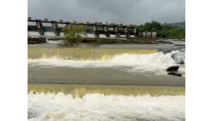
The irrigation department reported that water discharge from the Khadakwasla dam was increased to 2,400 cusecs on Sunday to manage inflow. Catchment areas of major city dams also received rainfall: Temghar (82 mm), Varasgaon (24 mm), Panshet (25 mm), and Khadakwasla (4 mm).
As a result, water storage across the four main dams has reached 18.4 TMC, a substantial rise compared to 5.7 TMC during the same period last year.